Tip 82: Use Point Auto-detect to quickly mark imported points on photos
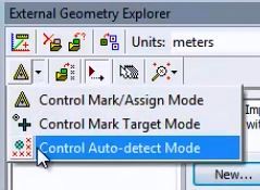
A recent update added the ability to use Point Auto-detect for Control point marking and Multi-point Transform point marking. This tool can help speed up marking and referencing, with the right kind of project and photos.
External data is sometimes used to set up a coordinate system or help with the solution. The external data is from a survey, from GPS, or some other measurement tool. The typical process for using this data is:
- import the 3D data (typically from a file),
- associate the 3D data points with points in the PhotoModeler project, and
- use this information to form a coordinate system transform (non-warping), or use this information to control the processing algorithm (often to strengthen it). The first one is called a Multi-point Transform and the second, Control Points.
Both these uses required a number of steps to create the internal photo points and assign them to the external points. Typically this is a long multi-step process.
With the new Auto-detect tool, these points can be marked and referenced on multiple photos at the same time as they are associated with the external data. A one step process. This is especially efficient for setting up an accurate coordinate system in drone / uav photography and photogrammetry. The video example below is photography taken by a DJI drone.
Once a feature is marked on a single photo, Point Auto-detect scans other photos, and automatically marks the feature where appropriate, and implicitly references them. And in this case of the EGE, implicitly assigned them to the external 3D data as well. All in one step. Much higher efficiency when dealing with external 3D data.
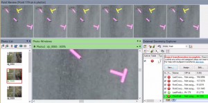
The following image shows a ground target being marked in the bottom photograph (that had been previously surveyed to produce an external 3D point), and with one click, the point is detected, marked and referenced on several photos (shown in the top pane). Click on image to see full resolution.
Watch the YouTube video for further detail on the process of assigning control or multi-point transform positions to new points in projects:


